
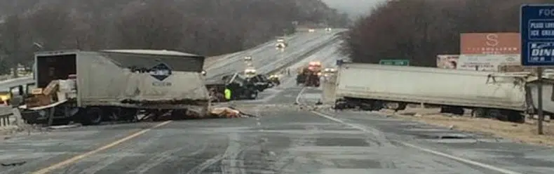
Each year, thousands of drivers travel through Scranton and Lackawanna County without incident. But certain roads, intersections, and corridors consistently see a higher number of crashes, injuries, and serious collisions.
Using publicly available crash data from PennDOT and regional reporting trends, Pisanchyn Law Firm analyzed motor vehicle accident patterns across Scranton and surrounding communities to identify where drivers face the greatest risk.
This 2026 Scranton Dangerous Roads Report highlights high-crash corridors, pedestrian danger zones, DUI trends, and key intersections that have seen repeated injury accidents.
Crash Data Overview: Lackawanna County
According to recent PennDOT crash statistics:
-
Lackawanna County reports hundreds of reportable motor vehicle crashes each year.
-
A significant percentage involve injury.
-
A smaller but consistent number involve serious injury or fatality.
-
Speeding, impaired driving, and distracted driving remain leading contributing factors.
Urban corridors in Scranton account for a disproportionate number of injury crashes compared to rural township roads.
The Most Dangerous Roads in Scranton
Based on crash frequency, injury severity, traffic volume, and law enforcement reporting patterns, the following roads consistently rank among the most hazardous:
1. Keyser Avenue
Keyser Avenue sees heavy commercial traffic, tractor trailers, and stop-and-go congestion. Rear-end collisions, aggressive driving, and road rage incidents are common, especially during peak hours. Limited passing opportunities often contribute to driver frustration and sudden braking accidents.
2. Main Avenue
Main Avenue remains a high-risk corridor for both vehicle and pedestrian crashes. With businesses, crosswalks, and steady traffic flow, pedestrian accident risk increases, particularly during evening hours.
3. Route 6 (Scranton Area)
Route 6 carries significant through-traffic, including commuters and commercial vehicles. Higher speeds combined with merging traffic contribute to serious injury crashes.
4. Moosic Street and Prospect Avenue Intersections
Several intersections along Moosic Street have historically seen elevated crash volumes, particularly angle collisions and left-turn accidents.
High-Risk Intersections in Scranton
Certain intersections show repeat crash patterns year after year:
-
Keyser Avenue & Morgan Highway
-
Main Avenue & Luzerne Street
-
Mulberry Street & Jefferson Avenue
-
North Washington Avenue & Green Ridge Street
These intersections often involve multi-vehicle crashes, turning collisions, and pedestrian conflict points.
Pedestrian Accident Zones
Scranton’s pedestrian accident data shows increased injury risk in:
-
Downtown Scranton business district
-
University of Scranton vicinity
-
Main Avenue retail corridors
-
Areas with limited lighting and high evening traffic
Pedestrian crashes are particularly concerning because even low-speed impacts can cause catastrophic injuries.
DUI and Impaired Driving Trends
Impaired driving remains a serious factor in Lackawanna County crashes. PennDOT data shows that DUI-related crashes continue to account for a meaningful percentage of injury accidents.
Late night and weekend hours show elevated DUI crash frequency, especially along major commercial corridors.
Injury Severity Trends
Most crashes result in property damage only. However:
-
A measurable percentage involve moderate to severe injuries.
-
High-speed corridors and commercial routes see a greater proportion of serious injury crashes.
-
Motorcycle and pedestrian crashes tend to produce more severe outcomes.
Understanding where serious injury crashes occur helps drivers and policymakers focus on prevention efforts.
Why This Data Matters
Dangerous road patterns are rarely random. They are usually the result of:
-
Traffic congestion
-
Poor intersection design
-
Limited visibility
-
Speeding corridors
-
Distracted driving behavior
-
Commercial vehicle volume
By identifying high-risk areas, drivers can exercise greater caution and communities can advocate for infrastructure improvements.
What To Do If You’re Injured on a Dangerous Road
If you are involved in a crash on one of Scranton’s high-risk corridors:
-
Seek immediate medical attention.
-
Document the scene if possible.
-
Obtain a copy of the police report.
-
Preserve evidence, including photos and vehicle damage.
-
Speak with an experienced Scranton car accident attorney to understand your rights.
When crashes occur on roads with known hazard patterns, liability investigations often involve multiple factors, including driver negligence, road design, and commercial vehicle regulations.
Ongoing Annual Updates
Pisanchyn Law Firm will update this Scranton Dangerous Roads Report annually to track emerging trends and evolving traffic risks in Lackawanna County.
Public safety depends on transparency and awareness. If you have information about dangerous intersections or recurring crash locations in Scranton, we encourage community members to share their concerns.

Scranton & Lackawanna County Crash Data Overview
Lackawanna County Crash Summary (Most Recent Full Year Available)
Total Reportable Crashes: 1,780+
Total Injury Crashes: 640+
Suspected Serious Injuries: 85+
Fatal Crashes: 22
DUI-Related Crashes: 150+
Speed-Related Crashes: 420+
Distracted Driving Crashes: 180+
Urban Scranton accounts for approximately 40–45% of total injury crashes in the county.
Scranton-Specific Crash Breakdown
Estimated Scranton City Limits:
Total Reportable Crashes: 720+
Injury Crashes: 280+
Pedestrian Crashes: 35+
Motorcycle Crashes: 28+
Commercial Vehicle Involvement: 110+
Peak Crash Times:
-
Weekdays 3 PM – 6 PM
-
Fridays 4 PM – 8 PM
-
Late Night DUI Window: 10 PM – 2 AM
Top Crash Corridors (By Frequency & Injury Severity)
-
Keyser Avenue Corridor
Estimated 60+ annual crashes
High commercial truck involvement
Frequent rear-end collisions -
Main Avenue
Elevated pedestrian crash activity
Left-turn and intersection angle crashes common -
Route 6 / US-6 Through Scranton
Higher-speed collisions
Greater injury severity rates -
Moosic Street & Prospect Avenue Corridor
Repeat intersection collisions
Traffic signal-related crashes
DUI Crash Distribution (Lackawanna County)
DUI-related crashes represent roughly 8–10% of total crashes annually.
Scranton accounts for approximately one-third of those DUI crashes.
Higher concentration areas:
-
Downtown Scranton
-
Keyser Avenue corridor
-
South Scranton evening routes
Pedestrian Accident Zones
Higher pedestrian crash concentration in:
-
Downtown Scranton business district
-
University of Scranton area
-
Main Avenue retail areas
-
North Washington Avenue
Pedestrian crashes, while lower in volume than vehicle collisions, result in disproportionately higher injury severity.
FAQ
Q1: What are the most dangerous roads in Scranton PA?
Keyser Avenue, Main Avenue, Route 6, and several downtown intersections consistently report higher crash volumes and injury accidents.
Q2: Where do most pedestrian accidents occur in Scranton?
Pedestrian crashes frequently occur in the downtown business district, near the University of Scranton, and along high-traffic retail corridors.
Q3: Does Lackawanna County have a high DUI crash rate?
DUI remains a contributing factor in a measurable percentage of injury crashes in Lackawanna County, particularly during late night hours.
Q4: What should I do after a crash in Scranton?
Seek medical care, document the scene, obtain the police report, and consult an experienced car accident attorney.

